
National Parks in New Zealand
 |
| Abel Tasman National Park |
New Zealand has a total of 13 National Parks covering over 30,000 square kilometres of land. They encompass some of the most beautiful and unforgettable parts of the country. Areas of New Zealand's National Parks form part of the country's three UNESCO World Heritage Sites.
In alphabetical order, the national parks in New Zealand are Abel Tasman National Park, Aoraki/Mount Cook National Park, Arthur's Pass National Park, Egmont National Park, Fiordland National Park, Kahurangi National Park, Mount Aspiring National Park, Nelson Lakes National Park, Paparoa National Park, Rakiura National Park, Tongariro National Park, Westland Tai Poutini National Park, and Whanganui National Park. Three are three national parks in North Island, nine in South Island, and one on Stewart Island.
History
New Zealand's National Parks date back to 1887 when the Tongariro National Park was first established. The latest national Park created was Rakiura National Park on Stewart Island in 2002. The 1980 National Parks Act established the terms of use of the parks and their preservation for future generations.
 |
| Abel Tasman National Park |
Abel Tasman National Park (1942)
Abel Tasman National Park lies at the north end of the South Island. It is known for its golden beaches, crystal clear water, and granite cliffs. The Wainui Falls in Wainui Bay is a 20-metre waterfall on the Wainui River in the national park. The river cascades over granite boulders into a deep pool below. The park opened on the 300th anniversary of Abel Tasman's visit in 1942. It is the smallest of New Zealand's 13 national parks.
 |
| A beautiful day in New Zealand with a snow-capped Mount Cook in the distance |
Aoraki/Mount Cook National Park (1953)
Aoraki/Mount Cook is an icon of the country and many visitors flock to Aoraki/Mount Cook National Park to see it. Altogether there are 19 peaks over 3,000 metres in the park including New Zealand's highest mountain. The park stretches 60 km on the southwestern coast of South Island. The park dates from 1953.
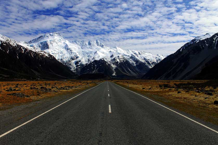 |
| Aoraki/Mount Cook |
Arthur's Pass National Park (1929)
Arthur's Pass National Park is on the east coast of South Island and is the highest pass over the Southern Alps. For the Maori it was known as a route between the east and west of the island. The park can be accessed easily from the city of Christchurch.
 |
| Arthur's Pass National Park |
 |
| Mount Taranaki (Mount Egmont) |
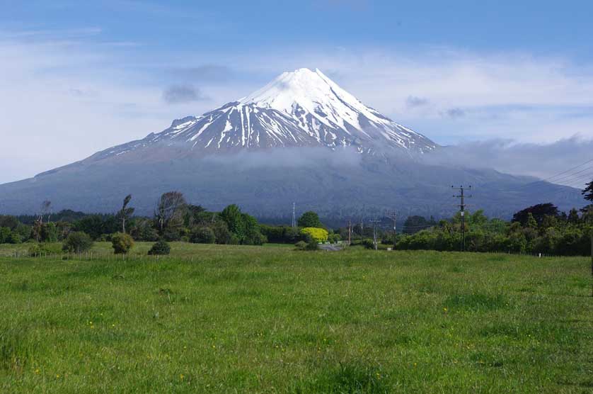
Egmont National Park (1900)
Egmont National Park lies close to the west coast of the North Island near the town of New Plymouth. It was the second national park to be created in the country in 1900. It comprises a forest reserve around the base of a presently dormant volcano, Mount Taranaki (Mount Egmont), with very high annual rainfall. Mount Taranaki last erupted over 150 years ago in 1854. The weather conditions have resulted in the growth of the broadleaf rain forest, marked by a total absence of beech trees.
 |
| Fiordland, New Zealand |
Fiordland National Park (1952)
On the southwest tip of South Island, Fiordland National Park is the largest of New Zealand's national parks. It occupies most of the southwest corner of the South Island and is a UNESCO World Heritage Site. The natural landscape here is one of beautiful forests, fiords, glaciers, mountains and valleys. Again, walking trails crisscross the area allowing access to some of the most striking natural scenery in the country.
Kahurangi National Park (1996)
Kahurangi National Park, the second largest national park, lies in the northwest of South Island. The endangered takahē bird has been fairly recently reintroduced in the park.
 |
| Mount Aspiring National Park |
Mount Aspiring National Park (1964)
Mount Aspiring National Park lies in the Southern Alps of the South Island, north of Fiordland National Park. Mount Aspiring / Tititea itself rises to 3,033 metres. Various walking tracks cross the area including the Gillespie Pass circuit.
 |
| Nelson Lakes National Park |
Nelson Lakes National Park (1956)
Nelson Lakes National Park is at the northern end of the Southern Alps. It is known for its pristine lakes, namely Lake Rotoiti and Lake Rotoroa as well as glacial valleys and snow-topped mountains. Camping, fishing and tramping are all popular pastimes within this beautiful region. Nelson and Blenheim are the nearest large towns about 100 km distant.
 |
| Pancake Rocks |
Paparoa National Park (1987)
Paparoa National Park on the northwest coast of South Island covers 430 square kilometres of limestone karst and several caves. The Paparoa Track runs through the park - one of the country's "Great Walks". Pancake Rocks on the coast are another popular sight in the park which is rich in birdlife.
Rakiura National Park (2002)
New Zealand's newest national park, Rakiura National Park is on Stewart Island/Rakiura off the southern tip of South Island. It is made up of previous nature reserves and state forest land.
 |
| The volcanic landscape of Tongariro National Park |
Tongariro National Park (1887)
The first national park in the country, Tongariro National Park covers the area of three mountains in the centre of North Island, all sacred to the Maori. The mountains, Ruapehu, Tongariro, Ngauruhoe are part of an area that is still active volcanically. The National Park is crossed by several hiking trails taking in the crater lakes and volcanic landscape of Tongariro and is of outstanding natural beauty.
Westland Tai Poutini National Park (1960)
Westland Tai Poutini National Park covers 1,320 square kilometres of territory on the western coast of South Island. Both Franz Josef Glacier and Fox Glacier lie within the park which has a wealth of flora and fauna including chamois, red deer, and tahr. Legal hunting is permitted within the park. The park is also noted for several spectacular waterfalls on the water flows from the glaciers.
Whanganui National Park (1986)
Whanganui National Park on North Island covers 742 square kilometres. It is a haven for birds including the brown kiwi.
Information
The Department of Conservation (DOC) operates visitor centres in all the national parks offering maps and brochures. They are an essential port of call.
Map
Related
Stay in New Zealand


0 Comments